
The collection of maps and vertical images below chronicle the changing face of the history of the Rattlechain area over the past 125 years or so. We believe this offers the most comprehensive and detailed view of this controversial site that has ever been published, with many images that people will never have seen before. It also provides gaps in evidence that many would like to see erased. They will not be. We will also not be overlaying the current site boundary of the lagoon over historic maps to present a fraudulent presentation that the site has always appeared fenced off and somehow contained seperately from the surrounding parcels of land. THE SITE HAS CHANGED OVER TIME, AND SO HAVE THE SITE BOUNDARIES, WITH SOME WASTE NOW OUTSIDE OF THE CURRENT SITE BOUNDARY.

This early 1890 map shows the Rattlechain Brickworks as “disused”. We do not know the reasons or length of time of the closure, but planning records suggest that the original “quarring operations” commenced in 1846. The Groveland and Waterloo Collieries to the West and South East occupy subtantial areas but are also marked as “disused”. At this time the landscape must have appeared particularly barren. The canal and railway lines perhaps providing a quick bypass through former industrial concerns. Interestingly the railway line above the Birmingham Mainline canal is marked as “The Stour Valley Line.” Another feature visible is the John’s Lane tunnel underneath the canal and railway lines. This is also rarely refered to as “Coopers aqueduct”. Old coal shafts are marked at both the South and North of the Rattlechain site. Just out of this picture immediately North of Rattlechain and Canal are The pumphouse brickworks.

In the 1904 map The Rattlechain Brickworks appears to be operating again. In addition “The Stour Valley New Brickworks” is now located alongside The Netherton Branch canal. This is just 5 years after the disastrous breach of the Birmingham canal. The Alan Godfrey reproduced Old ordnance survey map for Greets Green recalls “…the canal burst and the escaping water filled the 100-yards-deep marlpit and also about 3 acres of surrounding land.”
Numerous buildings are now shown at both of the brickworks. There is also what appears to be a liftshaft from the top of the embankment buildings into the worked out pit area. There is also the addition of The Upper Stour Valley sewage works below the location to the South of the site. Marked on here are “sluices” and “filter beds”. The disused Groveland Colliery appears to be being swallowed up by Barnett’s enterprise in brick making and there is also an overhead liftshaft descending into the Stour valley brickworks pit, though the site is not named on this map. John’s Lane appears as a track on this map cutting through the rattlechain and former Groveland colliery site and now joining the tunnel. There is also a footpath marked heading East from John’s Lane and then North East to link up with another that would become Rose Lane. John’s Lane would largely remain this way until the 1970’s.

This map 15 years later appears to show change to the buildings at both of Barnett’s brickwork sites. Though it is not marked here, the area adjacent to the Netherton Branch canal had by this time been operated by Albright and Wilson as a works tip. They then sold this to The Vono Company in July 1917 and continued to use it as a tip after this date to June 30th 1920. A letter from Vono to Albright and Wilson however dated May 21st 1919 confirms that Albright and Wilson renounced the right to carry on tipping to this date. The Rattlechain brickworks appears to have expanded westwards with a marked tramway or line entering a circular pit. The sewage works also appears to have grown in size with circular beds now apparent.

The 19 year jump in time is unfortunate given that it does not show the sites historic subtle changes. By now there is no trace of The Stour Valley Brickworks. A large area of water is marked in the area of the former Groveland Colliery. It appears that the Stour Valley pit area and the area of a pit in the former Groveland colliery have merged to form a figure of eight pool. So did the Stour Valley works expand into the other pit, and what happened to this area next- baring in mind the sale of Barnett’s other adjacent Stour Valley brickworks site?
A sportsground has now developed below that in the Vono ownership. Considerable changes in equipment are provided showing how the sewage works has expanded. The Rattlechain claypit is now starting to appear as the shape of the rattlechain lagoon area that we know today. It is clear that at this time clay was still being extracted from this pit. Planning records estimate that about 28,000 cubic yards of marl or 7 million bricks were created from the operation.

This very rare map dates from 1940. It was a map allegedly owned by “Captain” Sydney Barratt of The 8th Worcestershire Home Guard. Barratt became a big player in the Albright and Wilson company after the war. The map in pane A, confirms that the Rattlechain area was in the territory of this HG unit, with the Trinity Street Albright and Wilson run MOS factory also shown as being within their area. The map may be of a more amateur origin than the others, yet in many ways offers far more detail given that areas of water are marked. There are no markings to identify the brickworks site, probably because of the paranoia of such maps falling into enemy hands, but the brickwork buildings are identifiable, as is the pit that serves it. Interestingly there appear to be tracks circling the whole site. There are also several canal arms such as the Dunkirk branch above the old mainline, which have long been infilled.
A Google Earth image dated 12/1945 is of fairly poor quality and is also distorted by being incorrectly alligned. We have seen historic images which superceed these from this year held by English Heritage with some of them cloaked by “clouds”. Some establishments were disguised in this way during aerial photography.

©Reproduced by permission of English Heritage
This image from 1948 shows the location of Rattlechain brickworks next to the mainline canal and the location of the adjacent Rattlechain clay pit. It is not possible from this vertical image to gauge the depth of the site at this time, but it is clear that there is a small area of water adjacent to the main works. John’s Lane is visible as a track, as seen in the 1938 county series map, with the sewer works to the South of the site, with a boundary fence or track apparent. The other larger water filled figure of 8 marlhole mentioned above to the left was used by Vono works as a tip, but has no apparent connection to the Rattlechain site. Note how black it appears in contrast to the water in the canal. This whole area has now been filled in to provide “the autobase” industrial site, as will be demonstrated by subsequent images.
The apparent buildings beneath the Rattlechain brickworks are completely mysterious and are not mentioned in any planning applications mentioned held by Sandwell council. They are clearly visible in the pictures held by English Heritage. There is no layout of road or any buildings on any plans submitted in planning applications, nor do they ever make an appearance on any ordnance survey maps.
It has been suggested that they may in fact be stored bricks. It is possible that during and post war, stockpiles of bricks were kept for obvious rebuilding projects but we do not believe this is the case. We believe this given that no bricks appear to be being stockpiled in this way in the same location on site when it is claimed that the output of brick manufacture had dramatically increased after this date. The site layout appears to be more regimented with marked out roads. It was also in this area that the newly dug claypit, commenced in 1946 expanded into. The demolition of these apparent shelters must have taken place prior to the new marlhole being expanded, but there is no mention of what they were being used for.
Camouflaging and smokescreen buildings were all part of wartime deception, but unfortunately it appears that this can be kept long afterwards in peacetime too.
The brickworks at this time were still active. The picture below is a rare one of them still in use. It is taken from “Conurbation a planning survey” published in 1948. The view showing the canal basin entrance shows a train ride between Birmingham and Wolverhampton and the site is noted to lie roughly at the halfway mark of the journey.

Rattlechain brickworks Crown Copyright 1948

©Reproduced by permission of English Heritage
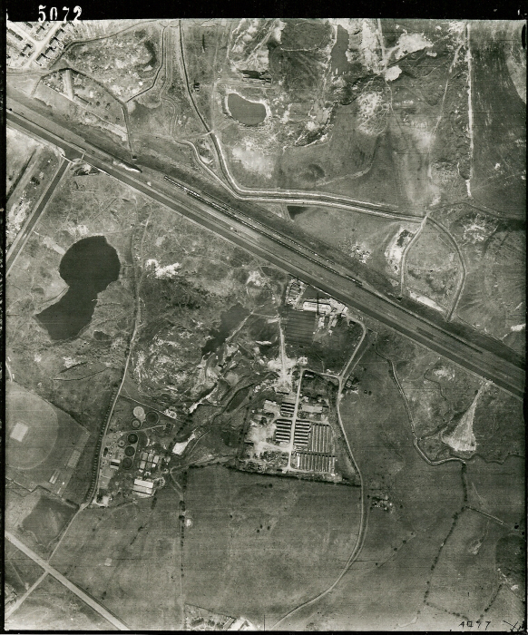
Striking changes are evident in this picture from 27th July 1955. The Rattlechain pool is now visibly defined, though it is a single pool with no secondary lagoon, though a smaller area of water is visible between the brickworks, sewage works and the new lagoon. The sewage works to the south have expanded to the East, a planning permission 1082 granting the construction of new filter beds, sedimentation tanks and expansion of the pumping station on 1/10/52.
The Vono lagoon to the West is still there. Barnett’s brickworks now appears to be extracting clay from where buildings were previously shown as planning permission 216 allowed them. This map confirms both areas as one large “tipping area”.
A boat is clearly visible at the discharge point on the Mainline canal and a channel that would have led down the North Embankment is also definable. Read about the historic waste dumping HERE. THIS PHOTOGRAPH DEMONSTRATES THAT ANY CLAIM TO THE SUBSIDIARY LAGOON NOT HAVING BEEN CONTAMINATED WITH WHITE PHOSPHORUS LACED TOXIC WASTE ARE UNSUBSTANTIATED.
The right of way along John’s Lane to the tunnel veers left between the two pools. The Albright and Wilson site at this stage included land that is now part of the autobase works. The pool edge to the East, which later forms the subsiduary lagoon and its embankment is now under the current John’s Lane.

This 1955 six inches to the mile map confirms changes at the site.

©Reproduced by permission of English Heritage
14th June 1961. Clear changes have occurred with a subsidiary lagoon now in place with a dividing causeway path. This is much smaller and less elongated than the current smaller pool. We can only wonder as to the lack of health and safety inplications which stanked off this area of highly toxic waste, and where it would have been scattered to. The main lagoon appears to have expanded towards John’s Lane and there is an outpost of land jutting out from the newly formed causeway path. A planning application to build a steel rolling mill at this time on the Vono land would see the rattlechain site change on its Western boundary.
At this point it must have been evident that more water was needed to cover the highly combustible waste contained in the lagoon. P4 production at Trinity Street was still in operation at this time, and the waste stream containing it would have been significantly more than in later years of use.
Correspondence with British Waterways from 22nd January 1963 confirms that Albright and Wilson were going to raise the water levels in the main lagoon.
Another Engish Heritage picture dated 30th July 1963 shows the causeway path dividing the two pools now more clearly defined. Visible white stainage from the North embankment at the discharge point from the canal is clearly identifiable. The adjacent Vono lagoon to the West of the rattlechain site has shrunk in size having been apparently partially infilled, but with what materials? Buildings are on the London Steel Works/ Autobase site for the first time as approved by permissions (outline) 3222 and 3289 “Erection of a steel rolling mill and ancillary buildings.” The brickworks and sewage works sites are also still definable in this picture.
The county series maps from 1965 and 1967 both identify the smaller subsidiary rattlechain lagoon kidney shape as still being as shown here. However they are wrong in respect of the Steel works/Vono site lagoon, which does not show as a waterbody on the plan, only as “spoil tip”

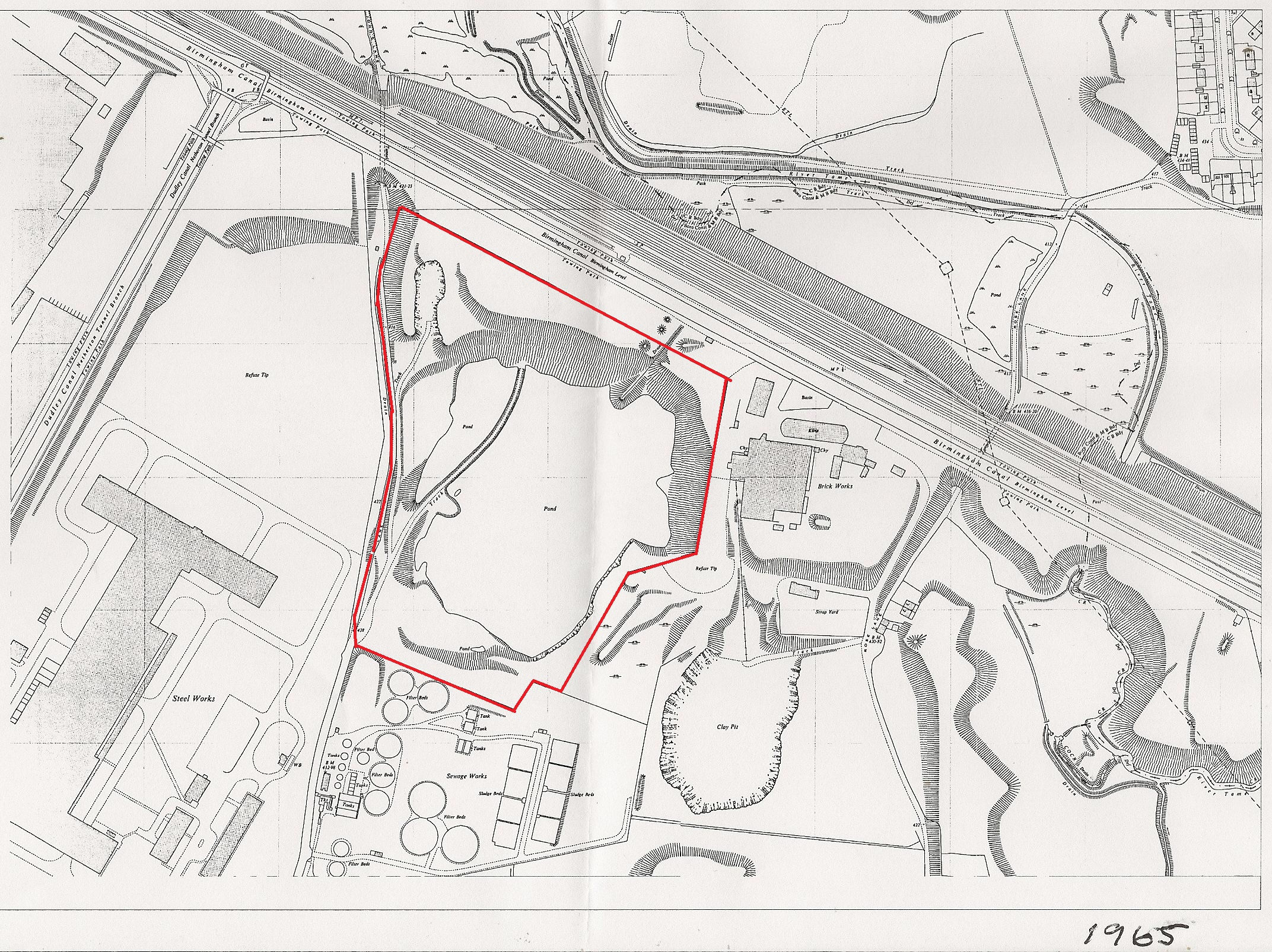
Rattlechain site boundary edged red 1965
The 1965 map shows both the rattlechain lagoon and subsidiary lagoon as it now appears, together with the newly dug rattlechain brickworks pit to the East. The brickworks buildings are still shown but a section between the two sites is labelled “refuse tip”. N.B there was never any planning permission granted in this area for this purpose. The discharge pipe into the lagoon from the canal is also shown.

‘Reproduced by permission of English Heritage’ ©Staffordshire County Council
30th May 1969 This picture sharply captures features of the pool and surroundings, at a time when official discharge from the canal was soon to cease, though we now know it continued for another three years at least. Note the pipe from the canal into the lagoon which is clearly defined. The subsidiary lagoon has extended in size and there are notable changes to the shape of the main pool. There appears to be curious excavations between the Rattlechain and adjacent steel works lagoon which is still clearly present and wrongly not included in the county series maps of 1965 and 1967, with the steel works site now expanding. The rattlechain brickworks site is starting to look derelict.
The 1970’s were to bring major changes to the whole area, with the end of processed waste along the canals and dramatic changes to site boundaries.

‘Reproduced by permission of English Heritage’ ©Staffordshire County Council
2nd October 1971
The year of final demise for the brickworks site. Clearly shown on this aerial photograph is the position and shape of the subsidiary lagoon and the boundary between The London Works Steel Factory and the Vono lagoon which is now severely shrunken in size. At this point it was being infilled with waste materials by Duport Properties Limited. The contrast in colour between the main lagoon and the smaller lagoon is also notable.The main lagoon appears discoloured to the same extent as the sewage works sludge beds. It remains questionable as to how Albright and Wilson were now able to discharge waste into the lagoon, given the lack of waste pipes from the only viable entrance on the South of the site in John’s Lane. This would appear to confirm the continued discharge via canal barge after 1970, as evidenced in many strong anecdotal accounts.
We have looked at what happened to the site boundaries in detail after this point and the changing face of John’s Lane HERE.
‘Reproduced by permission of English Heritage’ ©Staffordshire County Council
20th August 1981. All traces of the Rattlechain brickworks have now gone. Visibly defined boundary walls are now in place around 3 perimeters of the site and a track and turning circle on the edge of the Sewer works site is visible. “John’s Lane” now runs parallel with the subsidiary lagoon with a track also leading up to the canal, as the diversion order from 1977 confirms.
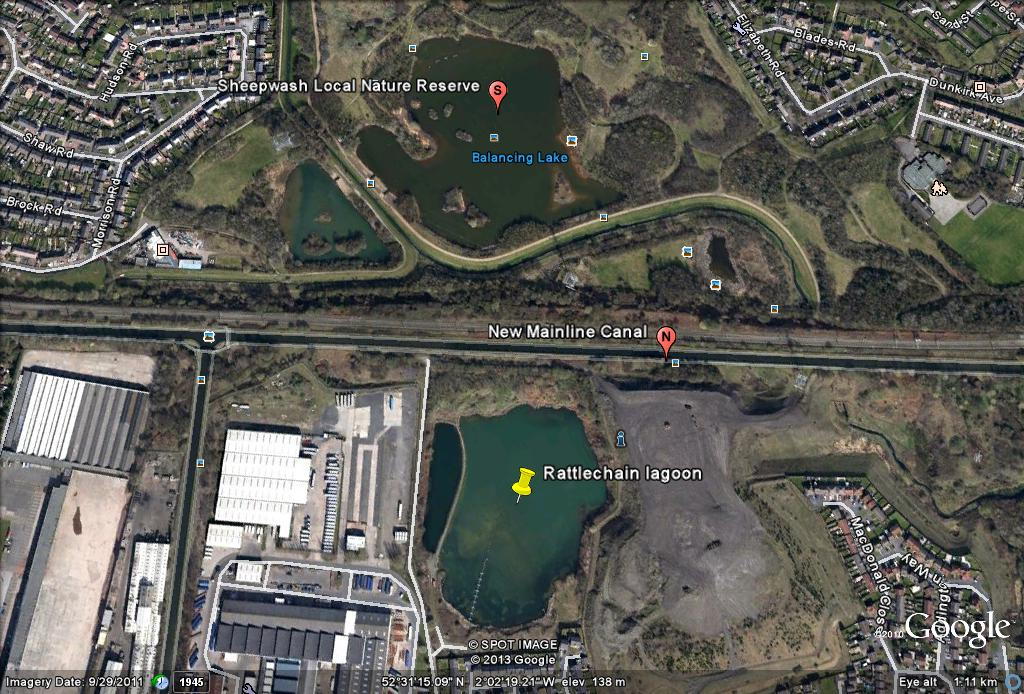
Sheepwash Urban Park is starting to be developed to the North of the Mainline Canal on the site of the old Pumphouse brickworks. There still appears to be no long discharge pipe into the lagoon from the south of the site at this time, giving question as to how waste was now being deposited at the site. There is anecdotal evidence that barrels of waste were manually sunk into the lagoon at this time on pontoons using rifle fire- this being carried out by the then Health and safety manager Mike Peters.
An English Heritage picture dated 5th July 1987 shows the autobase site appearing to have been levelled. For the first time a pipe from the beach area is visible jutting out into the water. The two lagoons are now virtually as they are today.

This image from around 1990, confirms the position of the discharge pipe located in “the beach area”. It would shrink in length and be superceeded by another pipe nearer to the main entrance. At the time of The Cremer and Warner report in 1991, the pipe is also shown as “a floating pipe” that can be manipulated to spread waste evenly out across the pool.

The following Google Earth images record the changes at the lagoon
1999
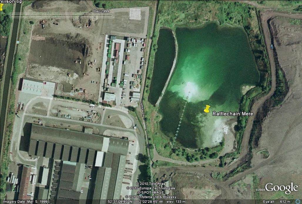
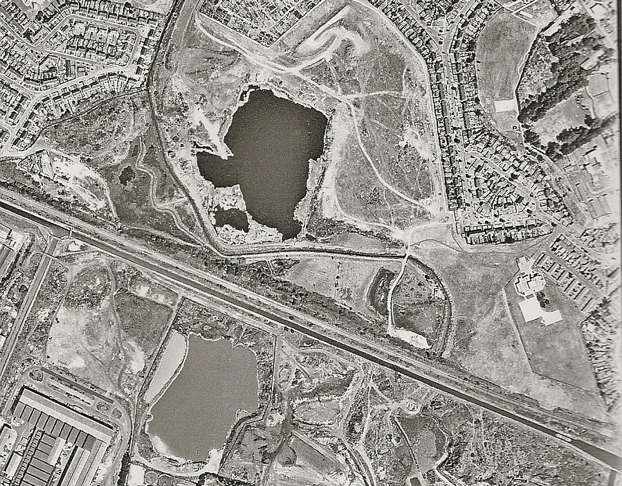
The autobase site is now populated by cars. A visible phosphorescent glow is eminating from the beach pipe. This is consistent with phosphine gas generation occuring on the site. The same dated snapshot also shows Sheepwash Nature Reserve to the North is now well established with associated pools and islands.

Birds eye view of pool prior to housing development. The large area of sediment around both the beach area and a massive island around the central pipe is clearly visible as is the phosphorescent glow emanating from it. The main discharge pipe has noticeably been moved from East to West though “the beach area” pipe was still in use.
From its humble beginnings as a “disused clay pit” the Rattlechain tip by 1999 can be seen clearly for what it has now become- a polluted toxic waste lagoon by Albright and Wilson. By now it was also starting to be refered by them and later Rhodia as the preposterous “Rattlechain Mere.”
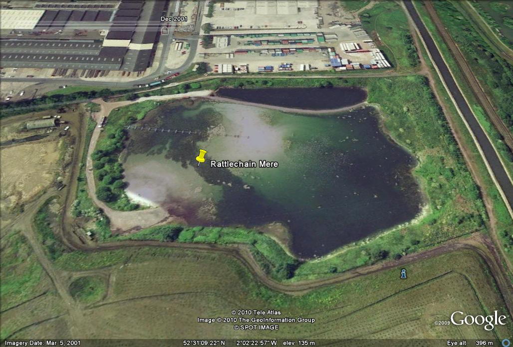
Large islands of waste created showing phosphorescent glow and eutrophication in December 2001

Saturated milky white solid deposits in “beach area” and large algal blooms on water as the tanker unloads. A tanker is discharging the waste into the lagoon as permitted by the waste management licence.

Sewage works to the South have been cleared by October 2003, nice glow on pool though!


Development of Wilson and Callaghan Drives has started on 2/11 2006, but the large island of waste is still visible at “The hazardous waste” site.


New years eve 2006, difficult to see where the landfill site ends and the rear gardens of the new houses will start.

8/10/07 The new housing estate appears complete. A new fence has been installed to block out the hazardous waste landfill, that many residents were unaware of. Some were allegedly told “it’s the place where the speedboats are kept.”
These pictures bring us up to the present day showing how residential development has been allowed to surround a hazardous waste site. We maintain that the siting of more housing around such a site makes the “clean up” of its historic legacy far less likely. From being originally used to build houses, the pit is now shielded from meaningful remediation by human guinea pigs living next to the toxic contents that have been buried beneath Rattlechain lagoon. The future only looks like living with Albright’s toxic toilet in your backyard.
